“Ummm… I’ve seen that same tree three or four times. I think we’re lost.”
For the past year I have been putting HuntingGPS Maps to the test on my Garmin eTrex Legend HCx. These maps work in tandem with my Garmin mapping software. I was able to download the California map and open it with MapSource. When owner/map developer Eric Siegfried and I spoke about the software and how it works, he also mentioned that the mapping software would be updated 2-3 times per year. Wow, really? Not many companies do that, but these guys update often because land ownership changes constantly and they want outdoorsman to know where they are and to be legal.
Installing the software was a challenge. You really have to know your mapping software and be able to load these maps, then find them and open them. I had to email Eric to figure it all out. I chalk it up to being a newbie to the GPS realm, but I wanted to give you all a heads up that it may be a bit frustrating at first, but don’t give up! Read on!
 |
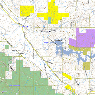
| Example map from my database. |
The maps are colored according to BLM map standards [BLM, State , Forest Service , private=white, US Fish & Wildlife , National Parks , Indian Reservations, etc.]
You will be able to see your position relative to public and private land boundaries. For example, if you are on a BLM section, your current location will show up on a yellow background. If you are on private land, your GPS will show your current location on a white background.
The software is quick, efficient and most of all accurate. It shows the borders between public and private land and give you a color difference so you won’t make the mistake of venturing onto private property.
This software is a great tool for hunter, but here is the downside – it’s only available to Garmin GPS units. Here’s the listing of units it works with. It’s only my opinion, but I think Garmin has one of the best GPS lines out there. The HuntingGPS Maps would probably look fantastic on the Oregon. I know that I am constantly referring back to my maps on the computer and comparing land borders to my hunting areas each time the newest version of the software is released.
Disclaimer: The reviews on The SoCal Bowhunter are solely my honest opinions. This product was provided to me for the purpose of review. I receive no monetary compensation in exchange for these reviews.


Be First to Comment